New Mexico Tech
Earth and Environmental Science
ERTH 471 / GEOP 572 - Geodetic Methods
Lab 4: gd2p.pl: static position estimation
UNAVCO bumper sticker
Note that you DO have to work on redoubt today!
Introduction
Last week you went through the exercise of determining a position from pseudoranges; basically by hand. Today we will start using GIPSY/OASIS (GPS Inferred Positioning SYstem and Orbit Analysis SImulation Software) for precise positioning. GIPSY is a collection of many programs and scripts to analyze GPS data (and other data).
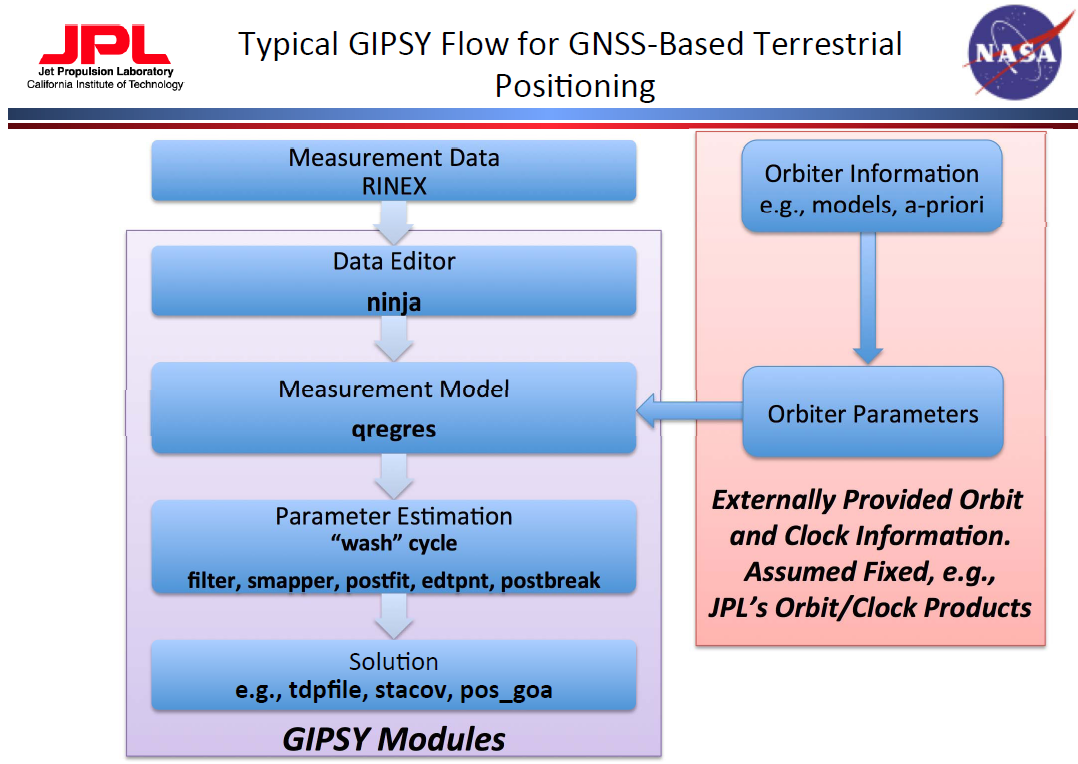
source: NASA/JPL
It is possible to string the programs together in a way that highly customizes your processing.
Obviously, that requires intimate familiarity with the tools so that you know exactly what
you're doing. gd2p.pl (GNSS data 2 Position) is a higher level interface to
GIPSY that allows you to process data for a single GPS/GLONASS receiver. It implements the
typical GIPSY workflow for kinematic and static positioning.
The command
$> gd2p.pl -h | moregives you full help and examples for this interface to GIPSY.
$> gd2p.pl -h_subGives a list of subtopics.
$> gd2p.pl -h_examplesGives a list of examples for different processing strategies.
In this lab, we can only cover some basics, I highly recommend that you take some time and explore this tool!
Setting things up: sta_info database and data files
Gipsy comes with a database, called sta_info that is composed of
several ASCII files; some we need to add information to be able to estimate positions for new stations. In my lab I keep
1 master copy of this database that contains the information for all the stations that
we process. Here, however, you will start out by creating your own copy.
- change into your working directory:
$> cd $GEOP572 - you should now be in a directory
/data/GEOP572/YOURNAME, where YOURNAME is your user name, if that's not true, go to LAB01 and fix your setup! (I did not do that for you when grading Lab01!) - copy the default instance of
sta_info:$> cp -r $GOA_VAR/sta_info . - an
$> ls -lisashould now list a directorysta_infoin your directory - the important files are
sta_id,sta_pos,sta_svec
These files are fixed format files! They have to match the format description EXACTLY!
Character by Character, don't use tabs, no shortcuts or everything goes down the drain.
I've warned you!
From the documentation:
sta_id

This file is the interface between the station identifiers in the
database and the outside world.  In this file, a given station name is
associated with a station identifier and a station number.  A given
station identifier and station number can be associated with more than
one station name.  This is allowed so that multiple names for the same
station can be handled.  The station number is currently not used, but
may be implemented in the future when all stations receive official GPS
numbers.  The following are examples of a few records:

 PENT   801 The following aliases for PENT were inserted on 9-May-1992 by fhw
 PENT   801 PENTICTON
 PENT   801 Penticton
 PENT   801 Penticton 1977
 PENT   801 PGCQ
 PENT   801 A station somewhere in Canada
 GOLD  1437 DSS10
 GOLD  1437 SPC10
 GOLD  1437 Goldstone Rogue Antenna
 SDAD   202 USC&GS HORIZNOTAL CONTROL MARK SOLEDAD PEAK 1932 RM1
 JPLM  7272 JPLMESA

where PENT, GOLD, and SDAD are all station identifiers, 801, 1437, and
202 are the station numbers and the character strings are station names.
These station names are the known aliases for this particular station
and are case sensitive.  The record format is:

(1x,a4,i6,1x,a60)

sta_pos

This file associates the station identifier with the station coordinates
at some epoch and the station velocity.  An example of a record is:

 JPLM 1992 07 01 00:00:00.00 1000001.00   -2493304.0630  -4655215.5490   3565497.3390 -3.20000000e-02 1.90000000e-02 6.00000000e-03 Mon Nov  9 15:07:31 PST 1992 itrf91 1992.5

(The record is stored on one line.)  The fields are:  The station
identifier; the epoch of the station coordinates (year, month, day,
hours, minutes and seconds); the duration of the station coordinates
(days); the station coordinates at the epoch (meters); the station
velocities (meters/year); and a comment.  The comment field could
contain the reference system of the coordinates.  The record format is:

(1x,a4,1x,i4,4(1x,i2)1x,f5.2,1x,f10.2,1x,3f15.4,1x,3e15.8,1x,a30)


sta_svec

This file associates the station identifier with the site vector and
antenna type at some epoch.  An example of a record is:

 JPLM JPLM 1992 06 00 00:00:00.00  31536000.00 ROGUE          0.0000     0.0000    0.0000     0.1630 l 1992 07 06


(The record is stored on one line.)  The fields are:  the "to" station
identifier; the "from" station identifier, the epoch of the site vector
(year, month, day, hours, minutes and seconds); the duration (seconds),
that the site vector is valid from the epoch; the antenna type,
corresponding to one of the antenna types in the pcenter file; the
station site vector; the antenna height; the site vector coordinate
system flag, where c indicates Cartesian coordinates (XYZ) and l
indicates local east-north-up coordinates (ENU); the date that the site
vector was issued; and a comment.  The record format is:


(1x,a4,1x,a4,1x,i4,4(1x,i2)1x,f5.2,1x,f12.2,1x,a9,1x,4f11.4,1x,a1,1x,i4,1x,i2,1x,i2)

(In this particular example, the "to" and "from" station identifiers are
the same.  This indicates that the site vector and antenna height in
this record are for the offset between the JPLM antenna and the JPLM
monument.)
Now for the data.
- We will use same RINEX file we've dealt with last time around: Abbott Peak on Ross Island, Antarctica
- I leave the organization of the data up to you, but I'd recommend you put this in a lab-specific directory and NOT into
sta_info - go to whereever you want to solve this lab and download the data
$> wget http://grapenthin.org/teaching/geop572_2015/lab03/abbz2000.15o
Task 1: Update sta_info
Your first task is to add ABBZ to the database.
sta_id
- In the
sta_infodirectory, add a line tosta_id - The 4 character ID is
ABBZ, the number can be zero, the ID should be descriptive; maybeAbbott Peak, Ross Island, Antarctica
sta_pos
- You'd best copy and paste a line and then edit that!
- The 4 character ID is again
ABBZ, the next columns are date/time. The rinex file is for 2015-07-19, which is a good start date to use - in the directory where you stored the rinex file run:
$> grep APPROX abbz2000.15o - copy the first 3 numbers, which are the apriori position we've used last week - see where this is going?
- paste the apriori position into the respective columns and make the decimal points align (make sure your precision is only 4 decimal places)
- The next 3 columns are a velocity, which we don't have, so set that to zero, and at the end add a comment that this estimate comes from the rinex file abbz2000.15o (not more than 30 characters though!!)
sta_svec
- You'd best copy and paste a line and then edit that, again!
- The first 2 columns are BOTH
ABBZ - Then you add the date, 2015-07-19, which is the day we're looking at
- Set hours, minutes, seconds to zero
- Use a large number for the numbers of epochs this record is valid:
946080000.00 - Then add the first 9 character of the antenna type. Many, but not all rinex files come with the antenna type:
$> grep ANT abbz2000.15o - It should start with
TRM - The last columns should all be zero, the last column can be a comment on where you got this information (abbz2000.15o)
Note that some of that information is time dependent. With this setup, if you were to try to process data from before 2015-07-19, you'd be out of luck! GIPSY doesn't have any information about the site in the database and you'll have to update it. If you do that, you'll have to recalculate and update the valid times for some of the existing entries - that's important! But we don't have to deal with this right now.
Task 2: Process
By default gd2p.pl will fetch orbit files from JPL's ftp server. We'll run several runs
on the same data and don't need to download the same file over and over again. Execute the following
commands (in the directory you'll be using in this lab, I will refer to this as $WORKDIR):
	$> mkdir orbit
	$> cd orbit
	$> goa_prod_ftp.pl -d 2015-07-19 -s flinnR -hr
OK, now we're ready to run the first run (there will be many this week and next week).
    $> cd $WORKDIR
	$> mkdir run1 && cd run1
	$> ( gd2p.pl 	-i $WORKDIR/abbz2000.15o -n ABBZ -d 2015-07-19 -r 300
					-type s -w_elmin 15 -e "-a 20 -PC -LC -F" -pb_min_slip 1.0e-3
					-pb_min_elev 30 -amb_res 2 -dwght 1.0e-5 1.0e-3
					-post_wind 5.0e-3 5.0e-5 -trop_z_rw -1.0 -tides
					-orb_clk "flinnR $WORKDIR/orbit" > run1.log ) > & run1.er
That's quite a mouthful, isn't it? A lot of the options here are default values, but this should demonstrate that there are many knobs you can turn to improve your position (or make it worse).
The options are:
    -i              input RINEX file, including path
    -n              name of site (used in sta_info)
    -d              date to process (used to get orbit, clock products)
    -r              measurement data rate for data editor to output into filter
    -type           type of positioning (s - static, k-kinematic)
    -w_elmin        minimum elevation angle cutoff (usually 7-15 degrees)
    -e              quoted string of flags that go to data editor (ninja)
                    here: use minimum arc length of 20 minutes, LC and PC data
    -dwght          PHASE and RANGE (note order!) data weights in km; usually
                    LC=1 cm, PC=1 meter
    -post_wind      Final postfit RANGE and PHASE (note order!) window in km for
                    edit point cycle (5 sigma)
    -pb_min_slip    minimum slip for inserting phase bread in postbreak (km)
    -pb_min_elev    minimum elevation angle at which postbreak criteria are applied
    -amb_res        Number of iterations for ambiguity resolution with wlpb file
    -trop_z_rw      random walk parameter for zenith troposphere, negative means
                    not estimated
    -tides          tide models to apply to station model. Empty list means no
                    tides modeled
    -orb_clk        defines type and location of orbit and clock products for
                    transmitting satellites
After the run look into run1.err, which contains the error messages of gd2p.pl.
You will have several errors getting the command line options right. Lastly you should end up
with an error like this:
ABBZ not found in s2nml's data base
find the correct command line option in the gd2p.pl help to change the default sta_info
database to $GEOP572/sta_info and add it to the command string;
re-run.
Theoretically, you should have these files in your directory now:
	redoubt:/data/GEOP572/gps/lab04/run1> ls
	abbz2000.15S         EDIT_POINT_FAILURE  postbreak_postEdit.log.0  rgfile      smooth_post_amb.nio  wash
	accume.nio           edtpnt2_ambig.nml   postfit2.nio              run1.err    smsol2.nio           wash.nml
	accume_post_amb.nio  GPS_antcal_ref      Postfit_amb.sum           run1.log    smsol.nio            wlpb
	ambigon.log          logs                postfit.nio               run_again   Sum_postbreak_logs
	amb_res_default.nml  point.txt           Postfit.sum               shadow      tdp_clk_yaw
	aregres.nio          pos                 prefilter.txt             smcov2.nio  tdp_final
	batch.out.0          postbreak.log.0     qmfile                    smcov.nio   tdp_final_pre_amb
	batch.txt            postbreak.nml       qregres.nml               smooth.nio  tpnml
That's a lot of files. They fall into several categories: log files, intermediate results, results. Most important
for you will be the run1.log/.err files that you created as they give you hints as to
where to trouble shoot. run_again is a shell script that gd2p.pl creates for you to rerun
the same solution, or edit it without having to edit the commandline history (make a copy of the file).
Obviously, there's trouble! EDIT_POINT_FAILUE (look inside) tells us that the "wash" cycle didn't
converge. We have large phase (LC) post-fit residuals and a large number of outliers:
$> cat Postfit.sum
Plot residuals
Lets generate plots of the phase and code residuals. Call the program
$> residuals.plwhich creates a file called
residuals.txt. Now separate the LC (GIPSY code 120) and PC (GIPSY code 110) residuals:
	$> awk '{if($4==120) print $0}' residuals.txt | cl h1 5 > run1_lc_res.txt
	$> awk '{if($4==110) print $0}' residuals.txt | cl h1 5 > run1_pc_res.txt
Note that cl is a script to manipulate columnar data that comes with GIPSY. What does the awk command do?
Generate the plots of the residuals
$> gnup -p run1_lc_res.txt -xl 'Hours' -yl 'postfit LC Residuals (cm)'Or use Matlab, or anything else. Typical LC RMS of residuals is ≶ 1cm; for PC it is 20-80 cm.
Deliverables: (submit via canvas!)
- the files:
sta_id, sta_pos, sta_svec - your
run_againscript - plots of LC, PC residuals
- answers to questions in bold
rg <at> nmt <dot> edu | Last modified: September 29 2015 14:35.